Road Safety Implications of Moose Inhabiting an Urban-Rural Interface
by Roy V. Rea
Natural Resources and Environmental Studies Institute and Ecosystem Science and Management Program, University of Northern British Columbia, 3333 University Way, Prince George, British Columbia, Canada, V2N 4Z9
Abstract
In an attempt to elucidate when and where moose-related vehicular collisions occurred in the city of Prince George, British Columbia, Canada, we conducted a city-wide survey of various agency record-keepers in 2004. We also conducted an inventory of all animal-collision countermeasures that existed in the city. Our results suggest that at least 40 collisions between moose and motorists occurred each year in Prince George in 2002 and 2003, and that these collisions occurred predominantly during November and June and along the outskirts of town. Over 70% of moose warning signs installed in the city were incorrectly placed relative to where moose were most often struck. Following placement of additional new warning signs in newly identified collision hotspots and implementation of an aggressive public awareness campaign, collisions between motorists and moose dropped by 58%. We recommend constructing a database to which city agencies and residents can contribute animal-movement and collision statistics. This would supply road safety planners with current data for making up-to-date decisions on mitigation measures.
Key Words: animal-vehicle collision, collision mitigation, driver education, habitat use, migrations, periurban, warning signs
Introduction
Urban landscapes possess unique attributes such as high human and vehicle densities and concentrated road networks (Nielsen et al. 2003). These landscapes are often constructed in low-elevation areas near rivers and valleys that frequently also provide seasonal rangelands and shelter belts for animals such as deer and moose (Mann 1973; Zwank et al. 1979; Whittaker et al. 2001). Despite the precarious mix of high-quality wildlife habitat with high human and vehicle densities, few studies have attempted to quantify the factors influencing ungulate-related vehicular collisions in urban/suburban areas (Nielsen et al. 2003; Ng et al. 2008) or recommend specific record-keeping methods to track such collisions (Finder et al. 1999; Premo and Rogers 2001). A lack of hard collision data and forecasting for such areas leaves managers guessing when and where the next animal-vehicle collision might occur.
Where urban centers have been developed within moose ranges, moose are struck and killed by motorists within city limits each year (Garrett and Conway 1999). Often, motorists colliding with moose are killed or severely injured (Rattey and Turner 1991; Sielecki 2004). Yet few studies (Alaska Department of Fish and Game 2003) have assessed the road-safety implications of locating city and periurban environments in moose habitats. A survey of residents in Anchorage, Alaska, revealed that 54% of residents were concerned about moose-related vehicular collisions (MRVCs; Alaska Department of Fish and Game 2003), while 20% of respondents surveyed in Prince George, British Columbia, Canada recently stated that they have had a moose encounter (some involving moose-vehicle collisions) within the city limits (MacDonald et al.).
To understand the trends associated with such collisions and identify hotspots where collisions recur, we initiated a multi-year, urban moose-vehicle collision mitigation study in the city of Prince George, British Columbia, Canada (53° 55' 01" N, 122° 44' 59" W; 1900' above sea level). Our objectives were to determine what records are currently kept on moose-vehicle collisions, elucidate when and where collisions occur within the city, assess what countermeasures are in place for collision mitigation, and make management recommendations to improve road safety. To determine the effectiveness of installing additional warning signs in the city areas we identified as hotspots, we compared MRVC data from before and after warning-sign installations and the implementation of an ad campaign.
Methods
To review current MRVC record-keeping practices, we selected and contacted 32 Prince George agencies that we deemed likely to maintain data on MRVCs within the city limits. Surveys were done in May and June 2004 over the phone or in person, as per interviewee preference.
Using data collected from agency staff, we identified collision "hotspots" within the city limits. We then calculated trend statistics for the time of year the collisions occurred and created a public advertising campaign to warn motorists when to be most alert and when they would be most likely to encounter moose.
Also, to determine where and when urban MRVCs were occurring in Prince George and how other jurisdictions were addressing the problem, we interviewed local agencies, reviewed the literature, and searched the internet. Recommendations for developing a robust MRVC record-keeping system were developed through a synthesis of interview data, literature reviews, and web searches.
Because no formal inventory of moose-collision countermeasures used in the city was on record, we methodically traversed all major city streets during the summer of 2004 and recorded any countermeasures in place that indicated to motorists that a potential for collisions with moose existed in certain areas. To determine which countermeasures might be effective, we reviewed the literature on mitigation measures used in other jurisdictions.
To determine if the countermeasures implemented as a result of our recommendations were helpful in reducing MRVCs within the city limits, we compared MRVC data from 2002 and 2003, the years immediately prior to our initial study, with MRVC data from 2006 and 2007, the years immediately after our initial study was completed and the recommended countermeasures had been installed.
Results
Of the 32 agencies we contacted to collect local information on moose-vehicle collisions, representatives from only 11 agencies felt that enough company information was kept on file for them to be able to participate in a meaningful way in our interview process. Information collected from the interviewees is summarized in Table 1.
By pooling data from records and interviews, we determined that in 2002 and 2003, an average of 39 MRVCs occurred within the city limits of Prince George each year. The most useful and consistent data, and therefore the data which we used for the study, came from the Conservation Officer Service and City (Municipal Public Works) Records.
Click images to enlarge
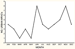
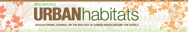
Figure 1: Number of moose-related vehicular collisions in Prince George, as recorded by the Conservation Officer Service between January 1, 2001 and December 31, 2004.
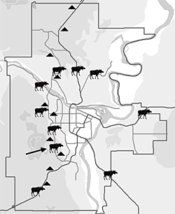
Figure 2. Road map of Prince George indicating collision hotspots (indicated with a moose icon), plotted using data taken from the Conservation Officer Service and City Records between January 1, 2001, and April 26, 2004. Triangles represent existing moose warning signs. Note: The arrow indicates the one hotspot that remained within the city following implementation.
Figure 3. Seasonal variations in MRVCs both before (2002–2003) and after (2006–2007) the study (2004) and implementation of its recommendations (2005).
Full-year records for 2001–2004 were provided to us by the Conservation Officer Service. These data indicated that collision peaks in Prince George occur in June and November (Figure 1). We also used these data along with data from the City of Prince George to identify collision "hotspots," which we arbitrarily defined as areas where four or more collisions occurred on a particular stretch of road (≤ 5 kilometers) between January 2001 and April 2004 (Figure 2). (No record-keeping system clearly and consistently indicated the time of day when MRVCs occurred in the city.)
Our reconnaissance survey of city roads indicated that the only countermeasure in place in Prince George was standard moose warning signs (60 × 60-centimeter black vinyl on yellow-colored aluminum). Three sets of two signs were found in areas where MRVCs were known to occur, while two sets of two signs were found in areas where no available data indicated occurrence of MRVCs (e.g., on Hwy 97, a major highway leading north out of town). Alternatively, seven areas where collisions were known to occur contained no signs. We therefore recommended installing signs where it appeared appropriate.
Eighty MRVCs were recorded by the local Conservation Officer Service over a two-year period between January 1, 2002 and December 31, 2003, the two years prior to our interviews, whereas 47 MRVCs were recorded for the same geographic area by the same office in the two years following the study and sign installations (between January 1, 2006 and December 31, 2007) (Figure 3). Collision patterns varied between study periods, with more MRVCs occurring in April, May, and August after mitigation measures were applied than before (Figure 3).
Using the same definition of a hotspot (≥ 4 MRVCs occurring on a particular stretch of road ≤ 5 kilometers in length over the two-year period analyzed), we identified only one MRVC hotspot within Prince George city limits after countermeasure installations. This hotspot is located on one of the most western and rural sections of town near the University of Northern British Columbia.
Discussion
Record-Keeping
As is common in other jurisdictions (Romin and Bissonette 1996, Sullivan and Messmer 2003), local Prince George agencies do not currently keep long-term records of wildlife collisions that are detailed enough or in an available enough format to be of much use in identifying MRVC hotspots or trends. The local police department appears to have the most comprehensive database. However, police data at the time of our study did not exist in a digital format; the data are sensitive in nature and therefore not made easily accessible for analysis. The City of Prince George has the next most rigorously-kept and most available data, but these records account only for collisions in which an animal is killed and city crews have been called in to retrieve a carcass. The Conservation Officer Service of the BC Ministry of Environment receives reports of collisions regardless of carcass presence and as such appears to have maintained the most consistent and robust database for the period in question.
Records from the provincial insurance agency responsible for universal basic automobile insurance coverage (Insurance Corporation of British Columbia, or ICBC) appear to be relatively thorough. Unfortunately, many drivers never report their collisions to insurance companies (West and Parkhurst 2002), and it is estimated that at least 25% of all animal collisions go unreported in BC (Sielecki 2004). Therefore, ICBC records include only collisions for which a material damage claim has been made. Most importantly, we found that ICBC records often lack specific information on the location and sometimes on the type of animal collision (moose vs. deer vs. dog).
Urban Moose-Collision Hotspots
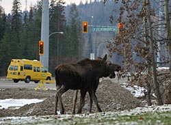
Without exception, all reported collisions both before and after the study period were recorded at the urban-rural interface. Although moose are known to wander into the more urban areas of the city, and deer have been struck in the downtown core, moose collisions consistently appear to happen along the outskirts or in the periurban areas of town. Prince George hotspots are characterized by fewer buildings and more green space, and are similar to those areas found by Nielsen et al. (2003) to be hotspots for urban deer collisions in two Minnesota towns. These areas also have higher speed limits (≥ 70 kilometers per hour) than those in downtown and residential areas (30–50 kilometers per hour). Higher speeds decrease response/braking time and directly influence the likelihood and severity of an accident (Joyce and Mahoney 2001, Sullivan and Messmer 2003).
Rodgers and Robins (2006) found that drivers traveling at night in excess of 70 kilometers per hour are highly likely to be overdriving their vehicle headlights and therefore much more likely to hit moose than those driving more slowly. According to other studies, most collisions with moose in the province occur at night when visibility is low and moose are difficult to see (Rea and Klassen 2006). Other studies clearly indicate that collisions peak between dusk and dawn (with most taking place one hour after sunset; Haikonen and Summala 2001), when visibility, and therefore reaction/braking time, is reduced (Garrett and Conway 1999).
Seasonal Trends in MRVCs
Moose collisions in Prince George occur most often in November and June. These data vary slightly from regional MRVC statistics by indicating a more pronounced collision peak in June and an earlier peak in winter than data from throughout northern BC (Rea and Klassen 2006). Although moose can be found within city limits year round, our data suggest their activities and movements around roads vary by season, with increased movement in late fall–early winter and in spring (Rea, unpublished data).
Throughout much of their range, moose are known to make seasonal migrations along elevational gradients. They move up to high country in the summer and down into valley bottoms in winter, where snows are shallower and browse along rivers and valley bottoms is plentiful (Harry 1957, Hundertmark 1998). Similar seasonal migrations have been noted among deer in urban areas (Phillips et al. 2001), with urban deer being more likely than rural deer to make such elevational movements (McClure et al. 2005). Trends detected in our analysis may reflect movement of moose in winter from the surrounding high country down to the valley bottom or "bowl" in which Prince George is located, and then up out of the city in spring.
Obviously, other factors may also contribute to increased moose activity near city roads at certain times of year. In late fall, ungulates are often observed eating roadside brush (Ng et al. 2008), which tends to stay green later into the fall than brush in the surrounding woodlands (Rea 2003). In winter, when nutrients are limited (Belovsky and Jordan 1981), moose in the city have been observed licking road salt from city roads and cars and browsing shrubs and trees growing in parks and residential properties (Figure 4).
Moving to roads is also thought to decrease pressures on moose from predators that are reluctant to use areas with high human activity (Berger 2007). This may account for movements at times of year when wolves can better hunt aloft crusted snows (i.e., late winter) or when wolves and bears are in search of newborn moose calves (i.e., spring).
Ticks are known to have detrimental effects on urban deer (Magnarelli et al. 1995). Because moose infected with winter ticks are known to become disoriented in spring when tick loads are heavy (Samuel 2004), and reports indicate tick-infested moose often wander onto roads, occasional peaks in spring collisions (as we see in data from 2006–2007) may be correlated with tick outbreaks and their associated effects on urban moose. Tick outbreaks are known to increase with increasing temperatures (Gubler et al. 2001), and temperatures in the Prince George area, as in much of North America, have warmed through the study period. Although speculative, this may help to explain possible interactions between spring tick population dynamics, their effects on moose, and MRVCs.
Effects of Mitigation Efforts
Our initial findings suggested that warning sign locations at the time of our study were misplaced relative to collision occurrence over 70% of the time. Immediately we recommended that signs be installed in collision hotspots, and that a robust database to record exactly when and where moose (and other animal) collisions occurred be designed and implemented until site-specific investigations had been conducted. Following this recommendation, road signs were installed by various agencies that had jurisdictional control within the hotspots, and most of the new signs installed were twice the size of those routinely posted, following the recommendation of Al-Ghamdi and AlGadhi (2004).
A total of nine radio ads, twelve newspaper articles, three letters to the editor, three television news spots, and a constantly maintained website were designed using our data to alert drivers as to when collisions with moose were most likely to occur. In addition, tips to avoid wildlife collisions were produced and publicized by the Wildlife Collision Prevention Program of the British Columbia Conservation Foundation in the three years following the study. An enhanced public awareness campaign about wildlife road hazards and wildlife-collision prevention continues in the Prince George area.
Our findings indicate a precipitous drop in vehicle collisions with moose in the two years after our initial study to an average of 23.5 collisions per year, compared to an average of 40 per year in the two years prior to our initial study. Collision statistics from ICBC correspondingly indicate a smaller drop in MRVCs around the Prince George area in 2006–2007 compared to 2002–2003 (from an average of 148 to 132 per year), but since these data include MRVC incident reports from over 100 kilometers beyond the city limits, they are less useful for determining the efficacy of our city-only mitigation efforts.
Collisions with moose in Norway were reduced by 50% following countermeasure implementations (Andreassen et al. 2005). The installation of novel wildlife warning signs had a similar effect in reducing deer crashes in the western United States (Sullivan et al. 2004). Stand-alone education campaigns about wildlife-collision risk do not appear to have been evaluated, but according to Hedlund et al. (2003) are likely to be useful if disseminated with very specific information about when and where animal strikes are likely to occur. This suggests that the local reductions in MRVCs that we experienced may be attributable to our combined approach of driver education and novel sign installations.
Although outside the parameters measured in this study, there is a real possibility that changes in movement patterns and population densities of moose in the area affected the number of collisions over time. However, moose densities in the surrounding region increased from 1.3 moose per kilometer2 (Heard et al. 1999) to 1.5 moose per kilometer2 (Walker et al. 2006) over the same general time period. Because reporting procedures by the Conservation Officer Service have not changed over this time, we have no reason to believe that the reduction in collisions is due to poorer reporting. On the contrary, we believe the recommendations we provided in our initial report to the city (2004), the subsequent media attention, and our new relationships with record-keepers would have increased diligence in MRVC record-keeping.
There are no indications that traffic volumes, posted speed limits, or other such variables changed between 2002 and 2007 that could cause a reduction in collisions. Interestingly, in combination with a drop in collisions, we noticed a dramatic change in seasonal collision patterns, with more collisions occurring in late spring after signs were installed than occurred in the same months before the study. Such a collision pattern differs from provincial patterns (Sielecki 2004), where peak collisions occur during the winter months with less than one fifth of MRVCs occurring in spring than occur in winter. As indicated by McClure et al. (2005), however, the behaviors, movement patterns, and activities of ungulates inhabiting urban areas aren't always synchronized with those of their more wild counterparts.
Recommendations
Database
Because a comprehensive data collection system on moose movements and exact collision event locations does not exist in Prince George, the number of annual collisions we initially reported for 2002–2003 and later for 2006–2007 likely underestimates the actual number of MRVCs. In 2003, a tow-truck driver responding to questioning at an MRVC crash site replied that he alone had responded to eight MRVCs in a four-month period on University Way, and this was not reflected in the data sets we reviewed.
A record-keeping system must be developed to address the issue of MRVCs in Prince George and wherever else MRVCs threaten the motoring public. Premo and Rogers (2001) reported on a GIS project that is being used to guide the formation of a deer-vehicle management plan in Amherst, New York. This system elucidates the spatial and temporal patterns of deer accident hotspots and shows promise as a monitoring tool for developing a deer-vehicle accident adaptive management plan. With exact locations and data about the time of day and time of year of collisions, mitigation measures for modifying driver and animal behaviors can begin to be entertained. New GPS technologies make this style of data collection virtually effortless compared to the paper and radio/phone-in records that are now currently used (Hesse et al. 2008).
We recommend a combination GIS/web-based and phone-in system, which would likely offer the most flexibility to users and allow for recording the most relevant data. A GIS-based system could form the backbone of an MRVC adaptive management plan similar to one currently under construction by Premo and Rogers (2001) for managing urban deer. Inviting residents to participate in the data collection could provide an important partnership role and sense of project ownership and would allow for incidents to be recorded that might not otherwise be collected under conventional methods (Lee et al. 2006). A web-based system where individuals can log on or call in and record the location of collisions or sightings could serve as a warehouse for such data. Such a site would complement a homepage where information about moose and other wildlife in the city could be easily located.
A record-keeping system should not include only collisions where moose are killed or cars are rendered inoperable, but also data from minor accidents, swerve-and-miss events, and even incidents where moose are simply seen crossing or moving around in areas adjacent to the road. In addition to spatial and temporal data, statistics on costs (material damages, city clean-up crews, emergency personnel dispatch, medical, etc.) should be collected in a rigorous way to enable more accurate assessments of the costs per collision event in the city, so that costs and benefits can be evaluated and incorporated into the rationale for the development and maintenance of mitigation projects.
Summary
Land development within the City of Prince George, as in many places across the globe, continues to expand into animal habitats. This expansion, combined with stable or potentially increasing populations of moose, suggests the need for implementing a comprehensive action plan to understand and combat urban MRVCs and other moose-human interactions.
Adopting a proactive and preventative stance has been recommended by the Anchorage 'Living with Wildlife Planning Team' (Alaska Department of Fish and Game 2003) and is also relevant in Canada. Under the "Wildlife-Human Conflict Prevention Strategy," the British Columbia Ministry of Water, Land and Air Protection calls for British Columbia government agencies, local governments, non-government organizations and individuals to change their behaviors and take some responsibility for preventing wildlife conflicts (Ministry of Water, Land and Air Protection 2003). Specifically, this strategy calls for more research into reducing ungulate-related vehicle collisions and for local government and non-government groups to address these conflicts (Ministry of Water, Land and Air Protection 2003). Similar calls, many of which are being addressed, have occurred throughout North America (Messmer and Messmer 2008).
Because motorists don't always associate the risk of hitting an animal as large as a moose with an urban environment, designating areas where collisions with moose recur is an important first step in mitigating such events. However, such designations must follow methods that rely solely on hard and rich collision data to justify countermeasure installations. Where collision hotspots have been identified, immediate action in the form of novel warning sign installations and the production and dissemination of collision statistics and warnings to motorists appears to help to reduce collisions. Signs, however, should not be considered a panacea for the problem of MRVCs (Pojar et al. 1975).
Once identified, collision hotspots could be surveyed to establish the most appropriate site- and species-specific countermeasures. Many options, such as grade separations, fencing, road lighting, habitat manipulations, sharp-shooting, and warning signs exist (Joyce and Mahoney 2001; Mastro et al. 2008). Equipped with several countermeasure options, site-specific investigations must be performed and solutions that address the reasons why moose and humans are interacting in specific sites must be developed.
Because movements and habitat-use patterns by moose change over time, periodic reexamination of MRVC statistics should be conducted and countermeasure placements regularly evaluated. Only after implementing long-term, serious mitigating measures will impacts to moose inhabiting the urban-rural interface be reduced and road safety improved for motorists bisecting these habitats.
Acknowledgments
Special thanks to Research Assistants Dorianna Hoekstra and Tracy Hunter. Funding for this project was provided by the City of Prince George, ICBC, the BC Real Estate Foundation Partnering Fund supported by the Real Estate Foundation of BC, Brownridge and Company Insurance Services, Sussex Insurance Agency, Nauroth & Associates Insurance Brokers and Barton Insurance Brokers. We thank Gina Layte and Teresa Frenkel at the City of Prince George. Special thanks to Gayle Hesse at the Wildlife Collision Prevention Program, who developed and administered the driver education campaign in the years following the initial study and who also reviewed an earlier draft of this manuscript. Many thanks to Gerry Moore and two anonymous reviewers for helpful comments on an earlier draft of this manuscript.